. índice . Prefacio . Preface . . aguas . 1 . 2 . 3 . 4 . 5 . 6 . . contamina 1 . 2 . 3 . 4 . 5 . 6 . . holocausto 1 . 2 . 3 . 4 . 5 . 6 . 7 . 8 . 9 . 10 . 11 . 12 . 13 . . lineas 1 . 2 . 3 . 4 . . hidrotermias 1 . 2 . 3 . 4 . 5 . 6 . . nuevas 1 . 2 . 3 . . Reconquista 1 . 2 . . hidrogeo 1 . 2 . 3 . 4 . 5 . 6 . . esbozos 1 . 2 . 3 . 4 . 5 . 6 . 7 . 8 . . corredorcentral 1 . 2 . 3 . 4 . 5 . 6 . . cordones 1 . 2 . 3 . 4 . 5 . . epiola 1 . 2 . 3 . 4 . 5 . 6 . . deriva 1 . 2 . 3 . 4 . 5 . 6 . 7 . 8 . 9 . 10 . 11 . 12 . 13 . 14 . . archivo 1 . 2 . 3 . 4 . . Halcrow 1 . 2 . 3 . 4 . 5 . 6 . . frentehalino 1 . 2 . 3 . 4 . 5 . 6 . 7 . 8 . . emicampanaoculto 1 . 2 . 3 . 4 . 5 . 6 . 7 . . Costa del Plata 0 . 1 . 2 . 3 . 4 . 5 . 6 . . Costa del oro 1 . 2 . . IRSA 1 . 2 . 3 . 4 . . flujos . . segmentos . . pendientes 1 . 2 . 3 . 4 . 5 . 6 . 7 . . delta 1 . 2 . 3 . 4 . 5 . . propuesta . 1 . 2 . . correconvectivo 1 . 2 . 3 . 4 . 5 . 6 . . plataforma 1 . 2 . . termodinamica 1 . 2 . 3 . . Sagoff . . ABL 1 . 2 . . congreso . . girh . . Acumar 1 . 2 . 3 . 4 . . evaluacion 1 . 2 . . BocaRiachuelo 1 . 2 . 3 . 4 . 5 . 6 . 7 . 8 . 9 . 10 . 11 . 12 . 13 . 14 . 15 . 16 . 17 . 18 . 19 . 20 . . StoDomingo . . urgenciasatadas 1 . 2 . . inundabaires 1 . 2 . 3 . 4 . . sinsustento 1 . 2 . . emisarios 1 . 2 . 3 . 4 . 5 . 6 . 7 . 8 . 9 . 10 . . UAG 1 . 2 . 3 . 4 . . áreas nuevas 1 . 2 . 3 . . acreencias 1 . 2 . 3 . 4 . 5 . . audiencia 1 . 2 . 3 . 4 . 5 . 6 . 7 . 8 . 9 . 10 . . Valls 1 . 2 . . contrastes 1 . 2 . 3 . 4 . 5 . 6 . 7 . 8 . 9 . 10 . . convexterna . . playas 1 . 2 . 3 . 4 . 5 . 6 . 7 . 8 . 9 . . Plan Maestro 1 . 2 . 3 . . Parque Norte . 1 . 2 . . ribera . 1 . 2 . 3 . 4 . 5 . . jurisdiccion 1 . 2 . 3 . 4 . 5 . 6 . 7 . 8 . 9 . 10 . 11 . 12 . . CSJNpisamr 1 . 2 . 3 . 4 . 5 . 6 . 7 . . zonas muertas . . Bermejo 1 . 2 . . Pilcomayo . . Uruguay 1 . 2 . . Paraná . 1 . 2 . . Asunción 1 . 2 . 3 . . Areco 1 . 2 . 3 . 4 . . Salado . . Samborombon . . Atalaya 1 . 2 . 3 . 4 . 5 . 6 . 7 . 8 . . PuntaPiedras . . Tuyú . . PuntaRasa 1 . 2 . . PuntaMedanos . . Mar Chiquita 1 . 2 . 3 . 4 . 5 . 6 . 7 . . Mar del Plata 1 . 2 . 3 . 4 . 5 . . Necochea . . Colonia . . MartinGarcia 1 . 2 . 3 . . montesdelplata . . botnia . . Puertos 1 . 2 . . formula1 . . disocio 1 . 2 . . senderos . . bajantes . . oceano 1 . 2 . 3 . . fitoplancton . . diatomeas . . hidrolinea 1 . 2 . 3 . . sustentable. 1 . 2 . . agua 1 . 2 . 3 . . hielo1300 . . antarticflows . . antarticmelts . . derrame . . luna 1 . 2 . 3 . 4 . 5 . 6 . . Trinidad . . prospectivas . 1 . 2 . 3 . 4 . . SantaCruz . 1 . 2 . 3 . . volcanes . . ley particular . . baires2060 . . aereadores . . Guaire . . marpampeano 1 . 2 . 3 . 4 . 5 . 6 . 7 . . Tamesis . 1 . 2 . . viajesedextra . . arena . . hospedero . 1 . 2 . . yacireta . . canalmagdalena 1 . 2 . 3 . . Barranqueras . . index .
Trogloditismo mecánico con sello N.A.S.A.
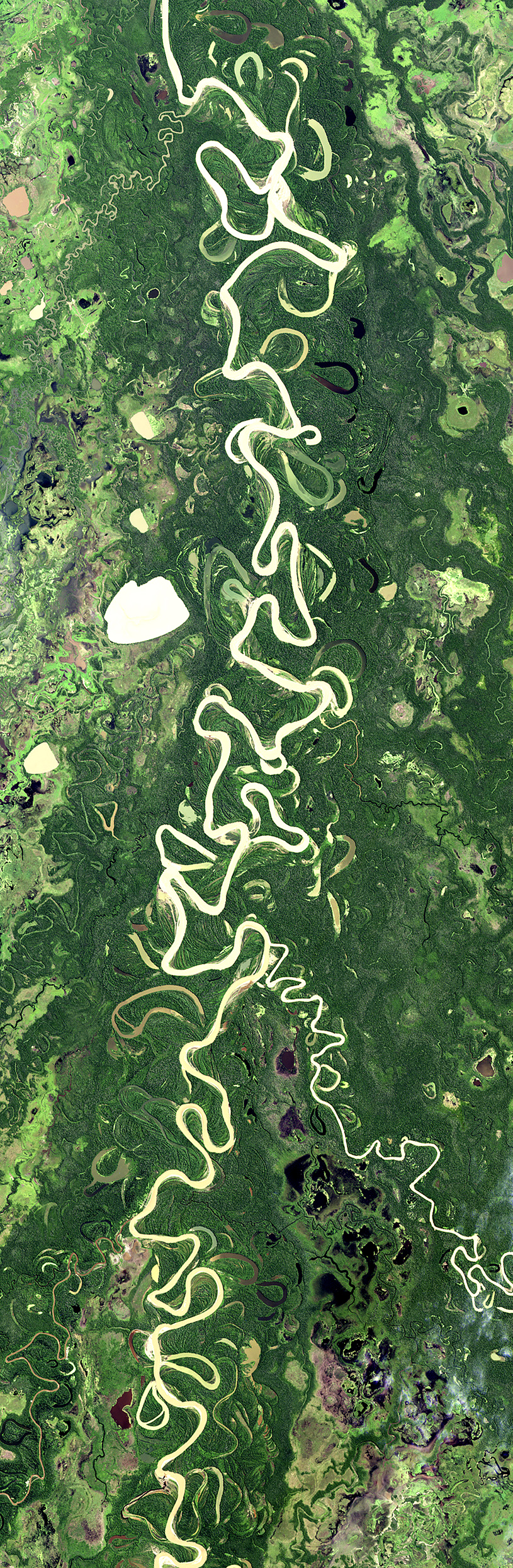
http://earthobservatory.nasa.gov/IOTD/view.php?id=84813
Earth’s largest river, the Amazon, snakes its way through a floodplain that is more than 32 kilometers (20 miles) wide. Sunglint from the water surface shows the numerous lakes and side tributaries on the floodplain.

Se ahorran de señalar que los 900 Kms que separan Manaos de la boca Atlántica cuentan con sólo 2 milímetros de pendiente por kilómetro y no son energías gravitacionales las que mueven sus aguas; sino, solares convectivas acumuladas en sus esteros aledaños. Cada cm2 de suelo en Manaos acopia diariamente más de 800 calorías. La energía solar acumulada en estas formidables cajas adiabáticas abiertas y bien naturales, reconocen más energía que toda la que consume el hombre en el planeta. Y sin embargo, veamos la cuadratura del círculo en las explicaciones de la propia N.A.S.A.
The extensive lakes have a longer history to tell. In response to falling sea level during the last Ice Age, the Amazon River cut a canyon tens of meters deep. Sea level rose again with rapid melting of the ice sheets, and to keep pace, the Amazon River bed also has risen. The rising river and bed have filled the canyon with vast quantities of sediment from the distant Andes Mountains in the process. The persistence of the lake depressions shows that this filling process is not yet complete.
http://earthobservatory.nasa.gov/IOTD/view.php?id=40247&eocn=image&eoci=related_image

The 38-kilometer-long (about 24 miles) Lago do Erepecu (LakeErepecu) in Brazil runs parallel to the lower Rio Trombetas (TrombetasRiver), which snakes along the lower half of this astronaut photograph. The Trombetas flows into the Amazon River from the north about 730 kilometers from the Amazon mouth. Recordemos que allí la pendiente es de 2 mm x Km.
Central Amazonia has many lakes like Erepecu—relatively straight, large waterbodies located just off the main axis of the large rivers. These lakes began as rivers that carved deeply into the landscape during periods of low sea level accompanying ice ages in the past 1.7 million years.
Ninguna huella de tránsitos glaciares en el pleistoceno reconoce el Amazonas a 730 Kms del Atlántico. Estos comentarios poco favor hacen a la N.A.S.A.
When sea level was low, the gradient from a river’s headwaters to its end at the ocean was steeper, and rivers flowed faster and carved deeper beds. During intervening warm periods, rising sea level reduced the gradient at the river’s end so much that it faced an impossible task—flowing uphill to the ocean. Límites del ojo mecánico luciendo a pleno.
The only way a river could have continued to flow to the sea is if it was carrying enough sediment to fill the deep river valleys carved during low sea level, creating a new “ground level” for the river to flow across.
Fabulación mecánica de alta certeza extrapolativa; que si Newton resucitara entendería por qué terminó su Vida contando papel moneda.
Many larger rivers like the Trombetas and the Amazon itself carried enough loose sediment to fill their deeply carved valleys, and then to trace sinuous courses (lower part of image) across the new beds. But smaller rivers that carried less sediment could not fill in their deep valleys; instead, the valleys acted like troughs. The river water poured in, but couldn’t flow out because of rising sea level, so lakes like Erepecu formed.
Si advirtieran la capacidad superlativa que tienen las energías convectivas para incorporarse a los sedimentos y llevarlos a viajes de 5000 km, ni Freud los salvaría de sentir el peso del abismo de sus errores.
A riesgo de errar en menos varias veces, estimo que los robos de energías convectivas a los cursos de agua en planicies extremas provocados por los sarcófagos de estos catecúmenos de Newton, superan al PBI anual conjunto de todas las naciones de la Tierra. Algo así como el número 10 elevado a la 14 ava potencia. Recordemos que el 23% de la energía solar que alcanza la Tierra va aplicada al movimiwnto de los fluidos y es 10.000 veces mayor que los consumos humanos, sin contar estas aberraciones.
Meandros
Over periods of years and decades, the courses of some rivers can be all over the map—literally. These shape-shifting, meandering rivers are naturally dynamic, "working their way across their valley floors, recycling floodplain sediment, and building both river and floodplain habitats as a result," said José Constantine of Cardiff University.
But what causes rivers to meander, and why do some meander more than others? These questions have been the subject of research for more than a century, and several hypotheses and studies have focused on the role of sediments.
The Amazon Basin—free of engineering controls and containing a wide range of sediment loads—provides a natural laboratory in which to investigate the relationship. Constantine and colleagues recently analyzed nearly three decades of Landsat imagery of the Amazon Basin.
They found that the greater the amount of sediment from external sources (glacial, volcanic, or human activity), the more likely the river was to meander; rivers and streams with lower sediment loads wandered less.
Those high-sediment rivers also saw more cutoff events, where crescent-shaped oxbow lakes are formed. One example is the Rio Mamoré, shown in the image pair above. The top image was acquired on June 11, 1985, by the Thematic Mapper (TM) on the Landsat 5 satellite. The bottom image was acquired on July 13, 2014, by the Operational Land Imager (OLI) on Landsat 8 . Turn on the image comparison tool to see how the river course changed over 28 years.The river flows toward the north (left in these images) and receives a large amount of sediment at the confluence with the Rio Grande.
The extra sediment enhances the growth of point bars—the lighter-colored, vegetation-free areas along the inside bends of the riverbank. According to Constantine, these features cause erosion and altered river flow that lead to a 1.7-fold increase in the rate of river migration downstream. In addition, meander cutoff rates doubled.
"Natural habitats that exist within floodplains depend on river migration to both renew habitat and maintain the natural functioning of existing habitat," Constantine said. "If we want to ensure a naturally functioning river environment, then we need to ensure the presence of an erodible river corridor and the supplies of riverbed sediment that are required for sustaining meandering river dynamics."
References and Further Reading: Constantine, J.A. et al., (2014, November 2) Sediment supply as a driver of river meandering and floodplain evolution in the Amazon Basin. Nature Geoscience 7, 899-903.
Hijitos nuestros
Veamos la naturaleza original que rodeaba las salidas de los arroyos Escobar, Garín, Claro y Las Tunas-Darragueira en 1863

y comparemos en la siguiente imagen hasta dónde la DIPSyOH y la AdA justifican sarcófagos con sello del Cuerpo de Ingenieros del Ejército de los EEUU y exprimen los jugos de la manzana de Newton en estos suelos con "pendientes" de 4 mm x Km

En este arroyo Las Tunas la provincia invirtió US$40 millones 'para generar este desastre irredimible de planteos ingenieriles en planicies extremas.
Al arroyo Claro lo borraron como "arroyo" y ahora figura en los planos de Geodesia como "desagüe".
Al arroyo Escobar que reconoce por la propia DIPSyOH caudales superiores a 700 m3/seg lo van a sacar por aquí. Ésta es la seriedad que guía.

Todos estos sarcófagos cuentan con el visto bueno del BID para resolverlos. Ellos nos regalan incluso las evaluaciones de impacto ambiental con una oficina especializada en estos dibujitos. Ver denuncia penal federal por http://www.hidroensc.com.ar/fraudebid.html
Ver http://www.muertesdelaliviador.com.ar/bid12.html y
http://www.muertesdelaliviador.com.ar/bid14.html
Francisco Javier de Amorrortu, 3/12/14
![]()